
News you can use
News you can use


U.S. Army Corps of Engineers inspections have judged the Milk River Levee unacceptable, a status that means the chance of flood in areas it's meant to protect is elevated and many could be forced to buy expensive flood insurance policies.
The Havre-Milk River Flood Protection Project was completed in 1957 after major floods including in 1938 and 1952 devastated the region. No floods of those proportions have hit the city since.
The levee system comprises the city-operated Bullhook Dry Dam unit and the county-managed Milk River unit. March 2014 and January 2015 inspections by the Army Corps said the Milk River unit does not meet standards. The Bullhook unit, despite it needing some minor attention, is within standards, Havre City Public Works Director Dave Peterson said.
Hill County commissioners Mark Peterson and Diane McLean have said they are concerned residents don't know about the consequences an unacceptable levee unit can cause.
Should major waters put enough pressure on the levee, it could give in and flood the area.
Despite its official unacceptable standing, Peterson said Monday, he believes the levee is "sound" and most likely capable of handling what it was built for. Nonetheless, because it has some problems, the chances it could fail are increased, however slight those chances are, the commissioners agreed.
The other concern is the Federal Emergency Management Agency remapping the area and putting a large portion of downtown Havre in the floodplains.
A community levee meeting was held Oct. 20 in the Northern Agricultural Research Center conference room. Among those present was Becky Dey of KLJ Engineering and Planning. Dey is in the long, arduous process of working with officials in Miles City to get that city's levee system replaced. Although Miles City's levee necessities and projected costs dwarf Havre's, Dey said, there are lessons Havre can learn from Miles City.
Miles City sits at the convergence of the Yellowstone and Tongue rivers. Residents have known since the '60s their levee system was deficient, Dey said. A second inspection in the '80s reaffirmed what the one in the '60s already established. As the city kept putting the project off and the years progressed, the sticker price climbed.
"The first Section 205 (inspection) in the '60s, they recommended to build a structure to protect against the 500-year flood. It was going to cost $1.6 million," Dey said. "They came back and did another in the early '80s and it was going to be about $11 million. Now we're looking at near $40 million."
The estimated price is not adjusted for inflation, Dey said, adding that expenses go beyond the construction cost.
"Now you've got the added cost of all these insurance policies that they didn't have back then because they weren't backed in to do that," Dey said.
Dey said that, just as high insurance costs slowed development in the city, affected home buying and selling and spiked rent prices in Miles City, the same thing could happen in Havre if FEMA remaps the area before repairs are made.
McLean said it's not out of the realm of possibilities for similar things to happen in Havre.
"Not only is this going to impact insurance requirements and be burdensome - as flooding insurance is very expensive - but people may not be able to sell their homes. You may not be able to get a loan to buy that home or that property. That kind of paralization to economic development is huge," she said.
A 2015 KLJ Engineering study said one-fifth of all flood insurance policies bought in Montana were for Miles City properties, which were projected to suck $596,000 in premiums out of personal budgets and the local economy. Residents who already had policies were projected to pay $55 million for flood insurance over the next 30 years, according to the study.
"Don't wait until it's urgent," Dey said. "Don't wait until FEMA comes in and remaps this community and 80 percent of your community is in the floodplain, because the moment that happens, now you're under national insurance guidelines and you're going to be racking out a bunch of money. Don't wait for that."
The good news for Hill County residents, Peterson said, is that the potential cost to repair the Milk River levee unit and what Miles City residents are going to have to spend to build their new unit is not even close. A rough estimate of what it would cost to repair the Milk River levee unit, Peterson said, is about $1 million. The commission is looking for programs and grants that would help taxpayers carry some of that potential financial burden.
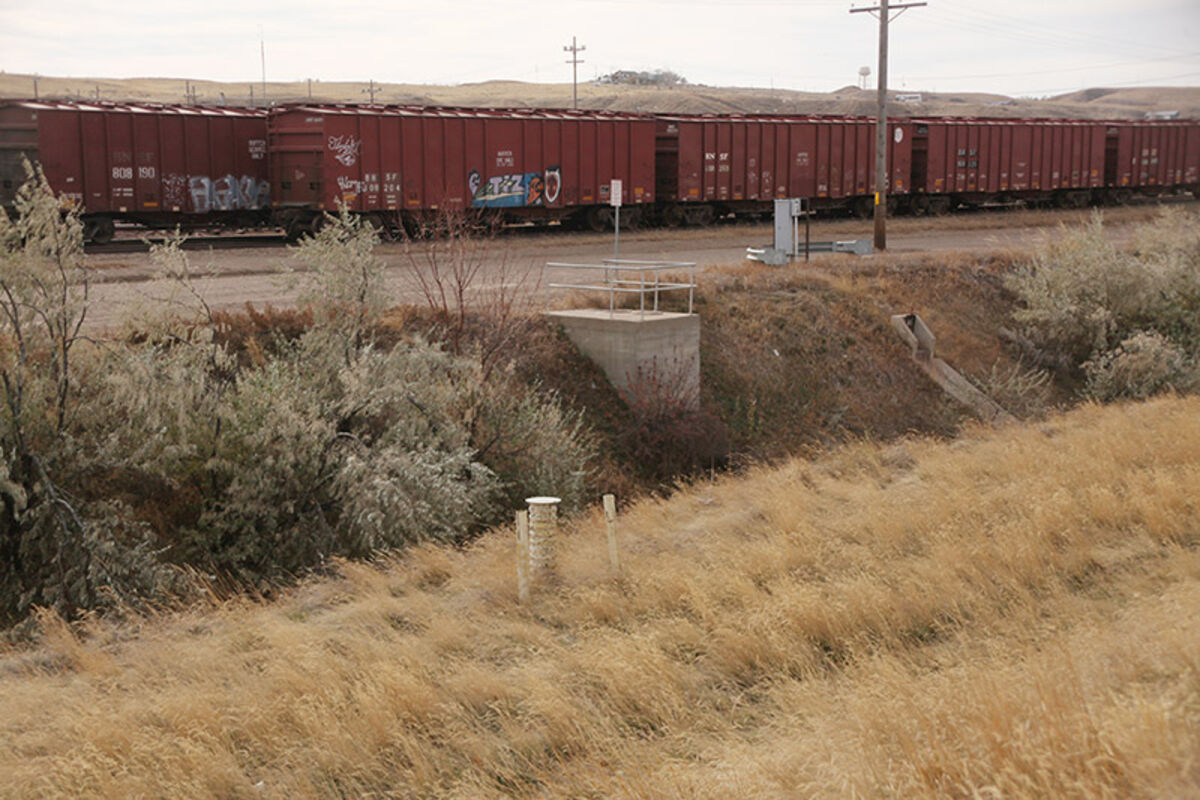
The Milk River Levee comprises a right bank and a left bank levee system. The right bank is about 2.87 miles long and encompasses 700 acres. It starts at the railroad tracks below Wahkpa Chu'gn Buffalo Jump and ends near the east edge of Havre. The left levee bank is about 0.95 miles long on the north side of the river and protects about 50 acres in North Havre.
The Corps regards the unit unacceptable because of operations and maintenance deficiencies.
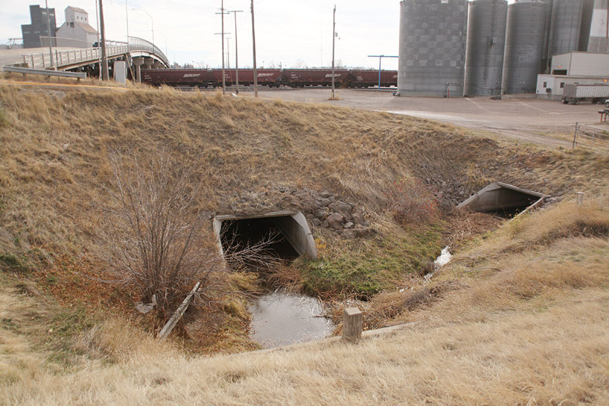
"There may be rocks on the edge of the river - you may have trees or shrubbery in the levee, too close to it. We've had multiple encroachments over the last 47, 57 years - people building a fence too close to the levee," Peterson said. "We have culverts that go under that need to be cleaned."
"We also have an opening on the west end, where the levee has been lowered for a gravel road to go across, and it's a railroad track. It's where the railroad did that. It's considered a deficiency because it doesn't meet that waterboard mark," McLean said.
The area both banks protect from flooding are most of downtown Havre and a large portion of North Havre.
Peterson said the total number of buildings protected by both banks of the Milk River levee is 1,094, with 924 of those being residential buildings. The value of all those buildings is just over $189 million, with $90,492,000 of that being residential value. The value of all the content in the buildings is estimated to be over $148 million. An estimated 4,392 vehicles are in the floodplains during the day. That number comes down to 2,945 at night.
While the chance of flood doesn't seem like a credible threat at the time, Peterson said, it wouldn't be foolish to ignore the erratic weather and destructive related disasters that are prone to grace the region.
"Well, if you look at, it we had drought this year, we had fire this year, we had a major snowstorm this year. What's left?" Peterson asked.
The degree of damage a flood will cause can vary.
"If you look at downtown Havre, it might be a foot deep. So it's a minor inconvenience," he said. "But it could be four or five feet deep. At that point, you're entering every downtown building, business, private drive - you are totally shutting down the business district of Havre."
The impact of a flood, Mclean added, would stretch beyond businesses and residents in the floodplains. And those who think they would be immune to a flood should rethink that notion.
"I live on a great big high hill south of town, 13 miles out there. You're not flooding me,'" McLean said. "'But my grocery store, my gasoline, my job, school system, the hospital - all of those are services I depend on and would have to go somewhere else.'"
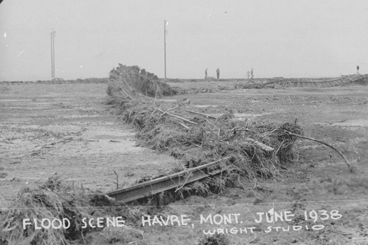
The levee system was built after two catastrophic floods washed through Havre, wiping out people's homes, businesses and, in some cases, their lives. The Montana Silver Jackets, a group of federal, state and local government agencies who work to curb flood risk, made a sign describing the scene in '38:
"On June 22,1938, a late evening cloud burst in the Bear Paw Mountains and made its way to Havre, resulting in what was then the worst flood in Havre history. Within an hour, about 1.75 inches of rain fell in Havre, bringing with it the runoff in Bullhook that runs through Havre. Businesses and homes were quickly flooded.
"The Hill County Courthouse basement flooded to the window sills. A fire engine was deployed to pump the three feet of water from the basement of City Hall, which was then located at the northeast corner of First Street and Fourth Avenue. The flash flooding continued through Gravelly Coulee near Laredo where several homes were located."
That flood killed 10 people.
As a result of the '38 flood, Congress authorized in 1944 the Havre Flood Protection Project. The Corps designed a levee system to control flooding off Bullhook and the Milk River.
"However, no funds were issued due to World War II and the Korean War," a synopsis of the Havre-Milk River levees by Great West Engineering says.
The flood of '52 was the result of massive snowpack after a cold, hard winter. The snowpack, melted - and melted - then poured into the Milk River from Rocky Mountains, and fed it until, in April, the banks burst.
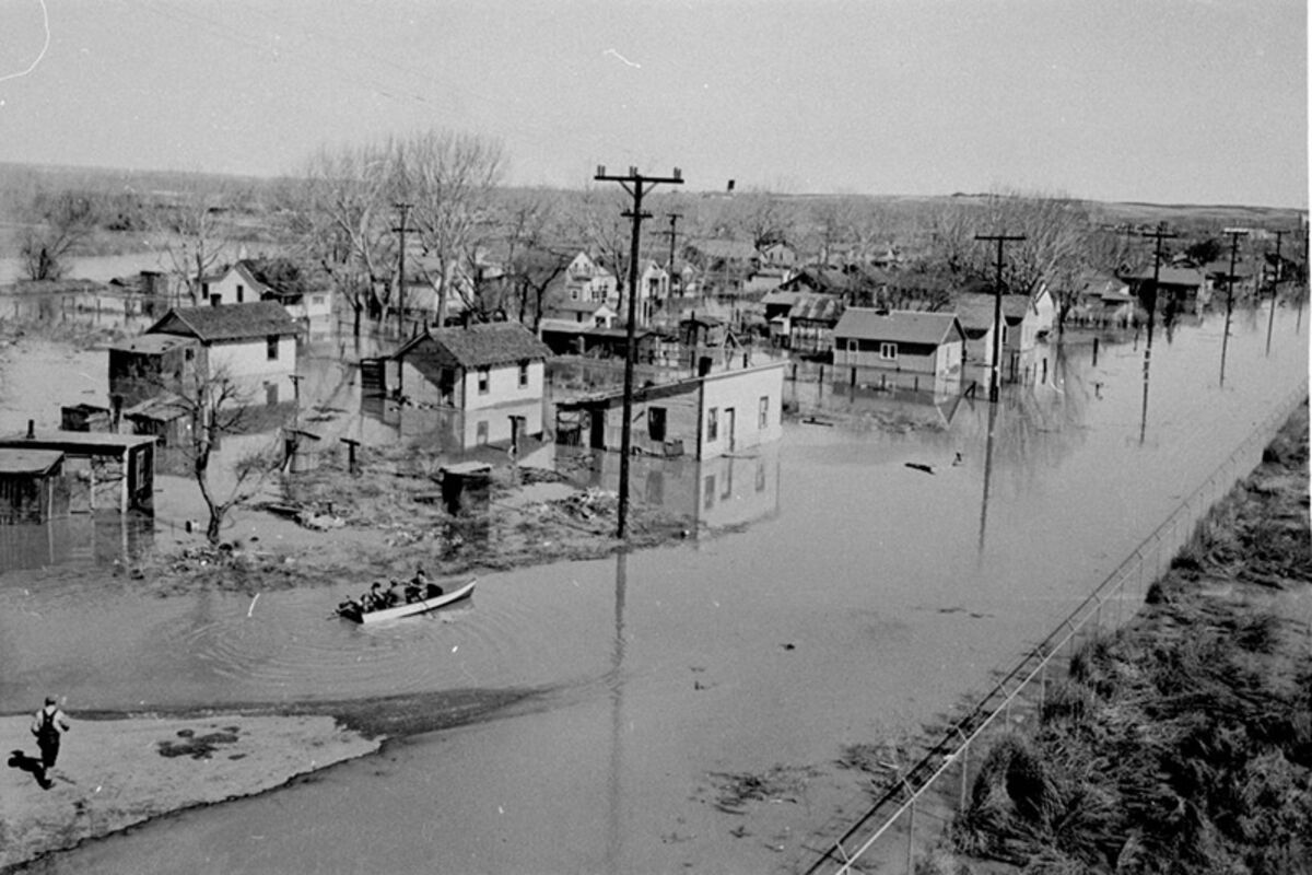
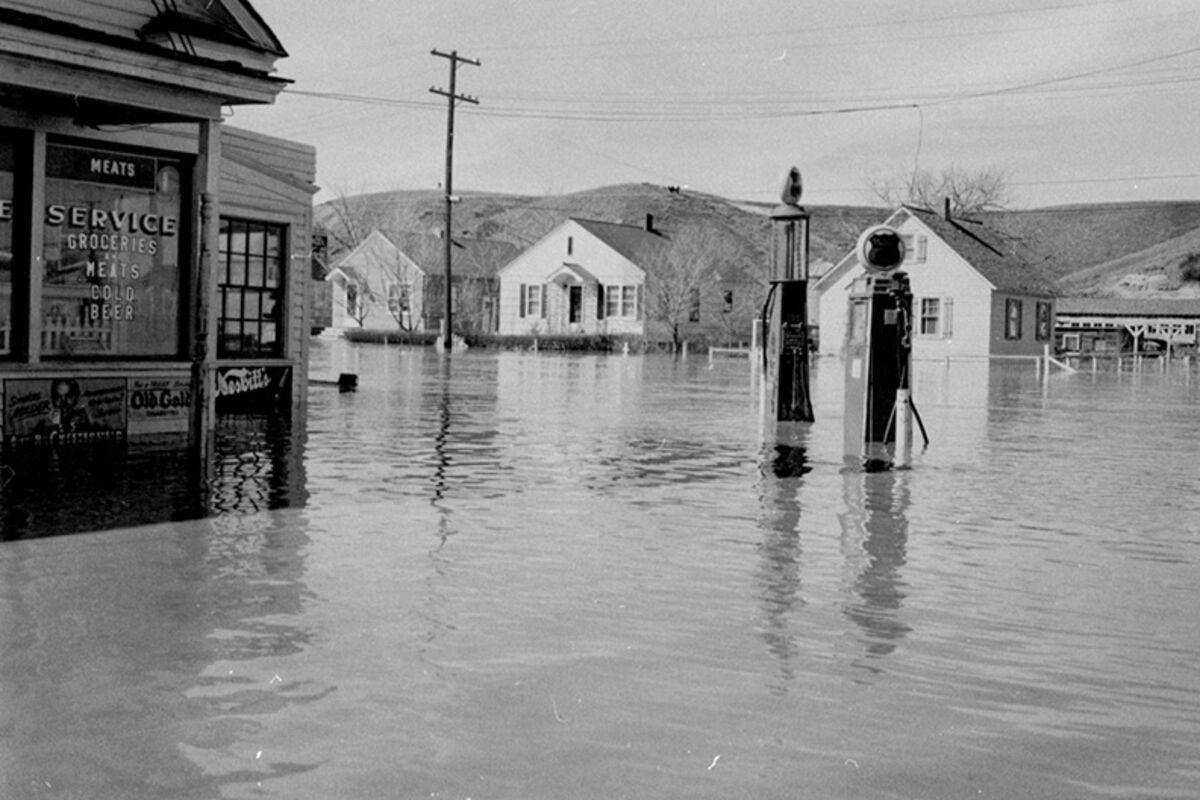
The Milk River flooded for three weeks, covered 300,000 acres, displaced more than 4,000 people, soaked 1,500 homes and caused an estimated $6.6-million in damages.
In Havre, the '52 flood left hundreds homeless. Pictures of the flood show residents rowing through town in skiffs, the water completely submerging the bottom of buildings.
After that flood, President Harry Truman pushed through funding for the Havre Flood Protection Project. The Corps finished the levee system in 1957.
The commission has already taken the first step to get the levee back up to par. A letter of intent, which keeps the region eligible for the Corps' PL 84-99 Rehabilitation Program in the event of a flood, was submitted and then approved Sept. 18.
The commission is at the foot of the next step, which is submitting a System-Wide Improvement Framework action plan, or SWIF. A SWIF includes details about what repairs and changes need to be done, a time frame in which those repairs will be done, how the repairs are going to be paid for and the expected completion date. That document has two years to be developed.
The commissioners said FEMA has not given any indication they will remap the area as of now.


Reader Comments(0)