
News you can use
News you can use
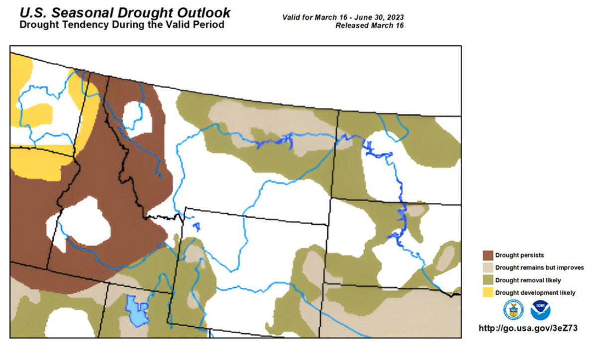
Long-range forecast predicts more improvement

The sun shining from behind clouds highlights the snow-covered ground west of Havre. With heavy snow in the fall through this month, the ratings for this area on the U.S. Drought Monitior have improved, with more improvement expected through June.

Fresh snow lightly covers the ice still covering Beaver Creek Reservoir Saturday.
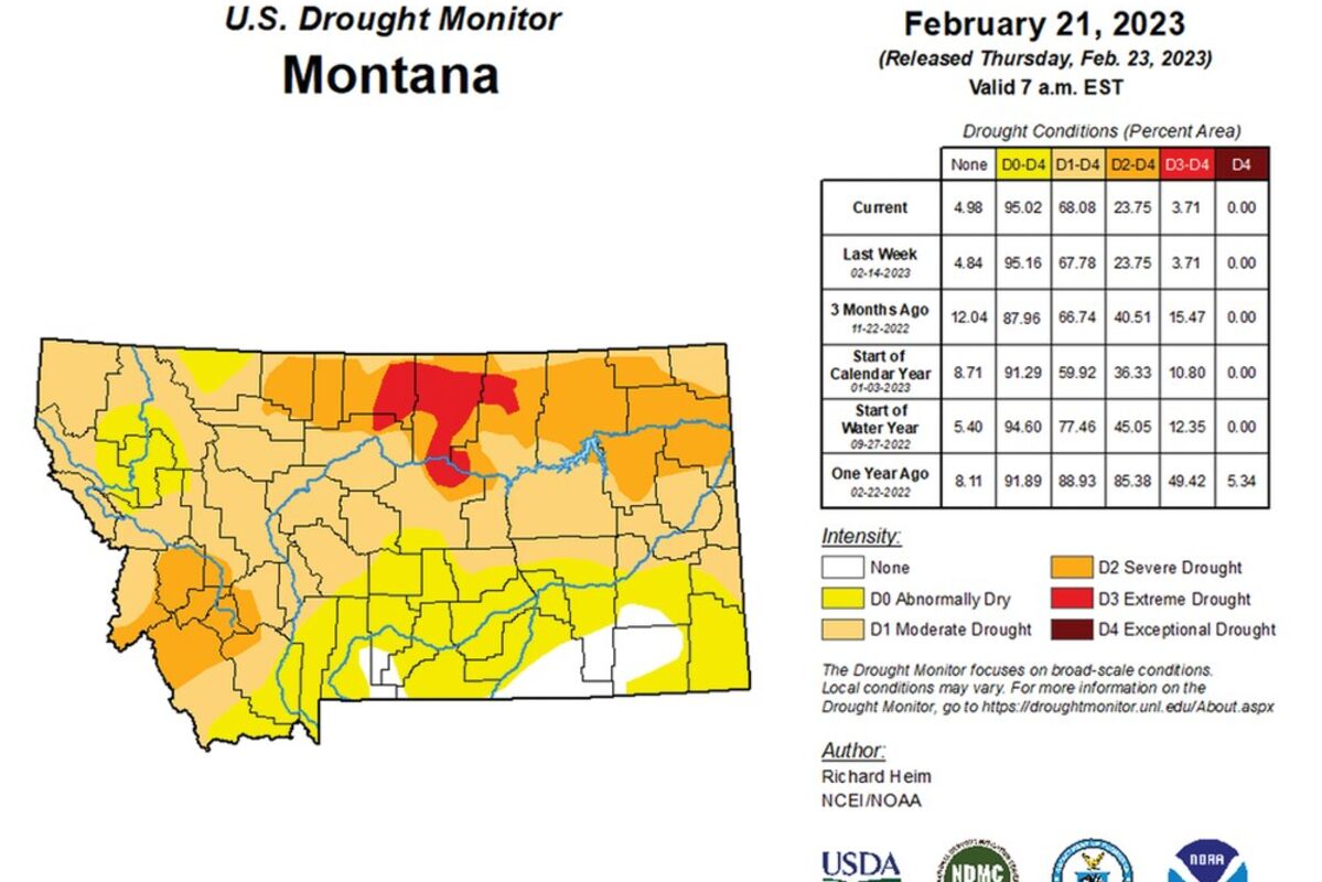

For the first time in months, Montana has no area listed on the U.S. Drought Monitor as in extreme drought, a possible sign that this part of the state might move out of extreme dry conditions for the fist time in nearly three years.
A patch across the northern part of the state, starting in Hill and Chouteau counties and running through Blaine County, to the North Dakota Border, still is listed as in severe drought, but a patch of the bright red Category D3 Extreme Drought finally has disappeared.
The March 21, 2023, Drought Monitor map was the first since July 13, 2021, that part of at least one of Chouteau, Liberty, Hill or Blaine counties as being in extreme or exceptional - the most severe rating given - drought.
The exceptional drought level occasionally started showing up in this part of the state Nov. 16, 2021.
Since May 19, 2020, the monitor has listed some part of one of those counties as being at least abnormally dry.
The snowfall last fall and this winter has helped immensely with moisture levels. Havre, as of March 27, the latest date available when this article was written, was listed at 1.25 inches of precipitation, just more than the normal value for that date of 1.22 inches.
And for the water year, measured from Oct. 1 through Sept. 30, the situation is much better. Havre as at 4.79 inches, almost 2 inches more than the normal amount of 2.86 inches.
Years of moisture shortages
The situation comes at the end of years of accumulated below-normal precipitation.
Although the heavy snow this winter has helped, Montana, and this region in particular, are still far behind normal with a large moisture deficit.
With multiple years of below-normal annual precipitation, National Weather Service lists Havre at more than 9 inches short from Jan. 1, 2018, to March 12, 2023, the most recent data available when this article was written.
But that is better than it has been. For May 25, 2022, the Havre area was listed at more than 10 inches short of normal precipitation since Jan. 2, 2018, with 40.68 inches recorded with the normal value 50.97 inches.
And this part of the Golden Triangle of Montana has been listed as in abnormally dry or drought conditions for much of those five years.
Years of unpredictable precipitation
And that period has been generally filled with long dry spells interspersed with periods of heavy precipitation, just enough to keep things growing, though usually not as well as in past decades.
After a relatively good start in 2017, this part of north-central Montana - along with most of the state - started to dry up.
The norm for Havre from Jan. 1 by the end of July is 7.5 inches of precipitation. In 2017, Havre had received about 3.5 inches.
By the end of August 2017, the moisture deficit increased to Havre having about 5 inches less than the norm of 8.5 inches, and it increased to an about 5.5-inch shortfall by the beginning of October.
Along with the impact on crops, the dry summer led to a number of fires in the region that were part of what is listed as the worst fire season in the state since 1910. The fires in this region included the July Fire near Zortman and Landusky in the Little Rocky Mountains, a vehicle-caused fire in northwestern Hill County that took the life of an Ohio woman, a lightning-caused fire that burned on both sides of the border between Hill County and Alberta, and the East Fork Fire in the Bear Paw Mountains that ended up burning more than 21,000 acres.
Then the region got moisture in October 2018, putting out fires but the storm was the signal of the harsh winter to come. More than a foot of snow fell the first week of October in a record-setting storm that broke trees and power poles, closed roads and knocked out electricity from Chester to Malta. Some people were without power for more than a week.
The weather turned comparatively mild for a couple of months, then, around Christmas, winter returned.
From mid-December 2017 to March 2018, the snow continued to pile up in the area, with several record-setting days of snowfall in the area and stretches of extreme cold.
And when it started to melt, it had nowhere to go. Fields and roads flooded, as did Chester, leading Gov. Steve Bullock to declare a state emergency for the region.
Then the region rapidly dried up in late April and early May 2017, with low levels of precipitation and hot, windy weather, leading some to be concerned that a drought could be on the way again.
Despite receiving nearly triple the normal level of snowfall in April 2018 with early storms - Havre received 8.9 inches compared to a normal amount of 3 inches - by the end of the month Havre had received .55 inches of moisture compared to the norm of .84 inches.
By June 26, 2018, National Weather Service had recorded .89 inches of precipitation for June at the recording station at the Havre City-County Airport west of Havre. That was short of the norm for June on that date - 1.84 inches - but with the snow that accumulated over the winter, it put Havre at a hundredth-of-an-inch over the norm for the year on that date, 5.57 inches of precipitation, and when the snow including the massive October snowstorm is included, Havre was at more than 2 inches more than the norm for the water year that starts Oct. 1, at 9.10 inches.
The weather later on that year made it difficult for producers, staying dry - too dry to plant winter wheat early on for many producers - then moisture came back and kept farmers out of their fields.
And the year ended up about 2 inches short of normal, with Havre receiving 9.87 inches.
A bitter February in 2019
The region saw fall-like weather the end of 2018 to the start of February 2019, but then winter hit for real.
December 2018 regularly saw highs in the 40s and 50s and an average temperature for Havre of 26.8 degrees. The normal average for Havre in December is 19.1 degrees.
December saw 1.3 inches of snow at the Havre reporting station, compared to a normal snowfall of 7.4 inches.
January 2019 saw a bit more snow. 6.8 inches compared to a normal average for Havre of 7.1 inches, but the weather in the area continuing to be warm, including highs still hitting the 40s and 50s in the early part of the month.
The average temperature for Havre January 2019 was 24.6 degrees, compared to a normal average of 18 degrees.
Then Havre saw temperatures go from a 44-degree high Feb. 1, 2019, to 41-below-zero seven days later.
That year, Havre recorded its second-coldest February since data started being recorded. Havre had an average temperature of minus 5.9.
The record was in 1936, when the average temperature for the entire month was minus 12.8 degrees.
1887 recorded an average temperature of minus 4.9 degrees in February while February 1891 was comparatively warm average of minus 0.2.
And the snow fell in February as well, though not like in the near-record year of 2018.
During the 2018 winter, February shattered snowfall records by the 19th of the month, with a new record of 32.6 inches. Although no more snow fell during the month, it was enough to beat the record set in 1977-78 at 18.6 inches.
In February 2019, Havre received 18 inches of snow.
March 2019 came in with a major snowstorm and continued warm weather, but then warmed up and dried up.
The precipitation level dropped as the temperatures rose from March on.
By the end of February 2019, which had 1.38 inches of precipitation compared to an average of .28 inches, Havre recorded 1.91 inches for the calendar year compared to an average of .61 inches.
The water year, recorded from Oct. 1 through Sept. 30, had 2.87 inches compared to an average of 2.02 inches.
But March 2019 ended up dry, with .2 inches of precipitation recorded in Havre compared to an average of .54 inches.
April 2019 was wetter, but still lower than normal, with Havre recording .74 inches compared to the average of .84 inches.
May 2019 saw 1.68 inches of precipitation in Havre, compared to an average of 1.74 inches.
That meant that by the start of June 2019, the region was a little above normal for the year, but was drying up due to the lower precipitation in March, April and May.
Havre had 4.52 inches for the calendar year compared to an average of 3.73 inches, and 5.94 inches for the water year, compared to an average of 5.14 inches.
June 2019 was a little less normal for precipitation, with the Havre area recording 2.20 inches compared to a normal amount of 2.49 inches.
And the dryness across the state showed up in the national drought monitor.
By the end of May, dry to slight drought conditions were shown in the northwest and northeast parts of the state.
By June 18, that had increase from abnormally dry to drought conditions across most of northeast Montana into northwest Blaine County, and dry to drought conditions in a larger area of northwest Montana and abnormally dry conditions in Beaverhead and Madison counties near Yellowstone National Park.
By the June 27 release, abnormally dry conditions were reported in Beaverhead and Madison counties and the dry region in the northwest portion of the state grew slightly, but the drought conditions in northeastern Montana were upgraded to abnormally dry. Northeast Blaine County remained in that condition.
And the weather remained dry through the early fall. For example, August 2019 saw Havre receiving .5 inches of precipitation, less than half the normal amount of 1.11 inches.
But that changed in September 2019, with Havre seeing 2.48 inches of precipitation compared to a normal value of 1.06 inches.
While October and December were dry, November 2019 made up for that with 1.55 inches of precipitation compared to a normal value of .49 inches. That led to Havre being above normal for the calendar year, with 12.32 inches compared to a normal amount of 11.82 inches.
But the following years saw increasing deficits.
In Havre, the amount recorded for 2020 was 9.37 inches, more than 2 inches short of normal.
Then 2021 saw only 7.67 inches in Havre.
2022 was better, with 10.48 inches, but still short of the normal amount.
Bizarre precip in 2022
The first half of last year kept the region in steady drought conditions.
By the start of June 2022, snow and rain across parts of the state had lessened drought conditions in some regions, but despite some rain falling in May in this part of Montana, extreme drought conditions still were listed here, already leading to some agricultural losses.
A patch of extreme drought was shown on the U.S. Drought Monitor released May 26 from the Rocky Mountain Front in Glacier County through Blaine County.
Extreme drought also was listed in a band from Pondera County south into eastern Lewis and Clark County and into Meagher County and parts of Park, Sweetgrass and Wheatland counties. Extreme drought also is listed in a small patch around the southeast corner of Madison County and southern Gallatin County and.
Most of the state had improved to severe or moderate drought, with a patch on the southeast edge of Montana moving up to abnormally dry conditions.
The very northwest corner of the state continued to be listed as having no drought, although abnormally dry conditions were added to the region where no drought was listed a month pervious.
And the weather in this region was taking its toll. Producers were saying they already had to sell off parts of their herds of cattle with a lack of grass and hay, and were watching what the weather brought to see if more sales in the next few weeks or months would be needed.
Havre by late February 2022 recorded 18.8 inches of snow since Dec. 1, 2021 compared to a norm of 22.6 inches. That included more than 3 inches in February, with a norm of 5.4 inches.
But the region saw little precipitation in following months, missing heavy snows that created blizzard conditions and shutdowns in southern and eastern Montana and North Dakota and rainfall that hit much of the state but not this area.
Some rain did fall in May, showers that brought a bit of moisture, but the region was still sinking deeper into a moisture deficit.
By May 26, 2022, the reporting station at the Havre City-County Airport listed .39 inches for the month compared to a normal value of 1.37 inches.
For the calendar year at that time, Havre had 1.43 inches of precipitation compared to a normal value of 3.69 inches, a 2.26-inch moisture deficit.
And the deficit for the water year had grown to 2.06 inches, with 3.27 inches of precipitation recorded at the Havre station since Oct. 1 with a normal value of 5.33 inches, a deficit reflected in the extreme drought conditions in Blaine, Hill and Liberty counties.
But some precipitation did fall in June 2022, including a storm June 13-15 that brought the first local major flooding since the federally declared disasters in 2010, '11 and '13,.
The system that brought the precipitation to this part of the state hit much of Montana, including causing disastrous flooding in and around Yellowstone National Park and east of there.
By June 16, Havre City-County Airport reported 2.87 inches for the month to that date, almost double the amount that fell from Jan. 1 to June 3.
By the end of June 2022, Havre recorded 2.99 inches of precipitation with the normal value 2.49 inches.
July remained above normal, with Havre receiving 1.84 inches compared to a normal value of 1.23.
But then it dried up again. From August through November, Havre received 1.69 inches of precipitation, more than two-and-a-half inches short of the 4.3 inches it usually receives in those months.
The dry conditions also led to the Eagle Creek Fire in the Bear Paw Mountains, where a fire that started Sept. 7 in a privately owned cabin on the western side of the mountains rapidly grew to more than 7,000 acres. Rapid response and effective cooperation between responding agencies, including local fire departments as well as state, tribal and federal entities, along with good firefighting conditions, held the fire to 7,225 acres.
Then December made up for the dry conditions.
Record snowfall
This region was blanketed in snow in December, with Havre receiving what was believed to be a new record for the month at 32.7 inches.
Havre's normal snowfall for December is 8.2 inches.
The snowfall dropped off a bit for January, with Havre recording 5.8 inches with the normal value 9 inches, but it came back for February with 7.1 inches, just greater than the normal value of 6.9 inches.
By March 28, the latest data available at the time this article was written, Havre had received 10.7 inches of new snow. The normal amount for the month is 5.2 inches.
For the snow year, starting July 1, Havre this year had received 63.6 inches of snow. The normal value for March 27 is 37.3 inches.
And it is making a difference in moisture levels, although it has not yet overcome the moisture deficit.
With the precipitation, at Havre, National Weather Service reported Havre March 27 at .4 inches for March, just short of the normal value of .41 inches.
For the calendar year, Havre had 1.25 inches of precipitation, just more than the normal 1.22 inches.
But for the water year since Oct. 1, Havre had 4.79 inches, almost 2 inches more then the normal value of 2.86 inches.
No one knows what the next months will bring, but Weather Service's Climate Prediction Center has a forecast for an equal chance of above-normal or below-normal temperatures and precipitation through June, which generally indicates about-normal weather for temperatures and precipitation.
That forecast is a general prediction, with extremes in either direction - hot or cold, wet or dry - still possible at any given time.


Reader Comments(0)